Planning a Quantix Flight
Planning your Quantix Flight requires the use of your Quantix tablet and should be done at a location where you have internet access.
- Power on the Quantix Tablet and launch the Quantix App.
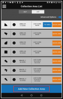
- (Collection Area List) Push Add New Collection Area.
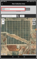
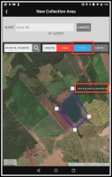
- (New Collection Area) Enter a name for your new collection area in the NAME field.
A default name will be populated for you if you do not enter one. You may change the collection area name at any time.
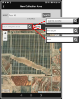
- (New Collection Area) Enter a Latitude/Longitude, City/Street, or Zip Code in the Search box to navigate the map to the area where your new collection area will be.
-
You may use your fingers to pan, zoom in, and zoom out on the map to navigate.
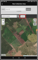
- (New Collection Area) Push CREATE to enable the map draw capability.
- (New Collection Area) Click on the map to draw an outline of your collection area.
Collection areas can be up to 400 acres.
-
(New Collection Area) Push FINISH, or click on the first point to complete the shape.
Click here to see a brief video demonstration of drawing a new collection area.
 Defining Collection Area Shapes
The Quantix Flight Planner has been tested on a variety of shapes and there are an infinite number of different field shapes that you can draw.
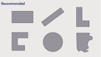
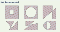
In general, your collection area should be:
- A closed polygon with no "holes"
- Fewer than 100 points or corners.
- As simple as possible to perform.
The examples below will help you select a reliable shape for the Quantix Flight Planner.
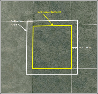
To ensure the highest quality product, draw your collection area with an additional 50-100 foot buffer around the location that you are interested in.
This allows software programs to more accurately stitch the area of interest, as the edges of a completed stitch tend to warp.
There are many options on where to place your Quantix for launch. This location will be considered ‘Home’, and will also be the planned landing location.
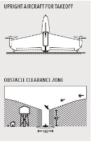
The aircraft will launch vertically from this location to an elevation of 100 feet before switching to forward flight mode.
In general you want to choose a location that is:
- On flat and even ground
- Clear of all obstacles within a 50 foot radius
- At least 100 feet away from all objects that are over 80 feet tall
Choose the Best Launch Location
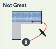
A Return Home Path Could:
- Fly over adjacent areas
- Fly into an unsafe area
- Fly into an undesirable zone
This launch location results in long Return Home paths outside the area.
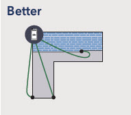
Any Return Home Path Would:
- Fly over intended areas
- Fly in a safe area
- Not fly in an ideal path
This launch location at least keeps return paths over more of the area.
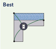
Centrally-Located All Return Home Paths:
- Have best line-of-sight
- Fly directly over intended areas
- Fly in a safe area
This ideal launch location is also centrally located to minimize the time to execute a Return Home.
Use Your Best Judgment — Select the best possible launch location based on obstacles, neighboring fields, and prevailing winds.
